
BreakOnThru.org
DISCOVERING THE FUTURE BY REVEALING THE PAST

THE SAINTED MISSIONARY REVEREND DAVID BRAINERD AND THE GREAT AWAKENING
1744 - 1747
by Jon Sinatra
A.D. - 1744.The lone rider crossed from New York, over Hudson’s River, and into New Jersey, having received orders to go to the Indians at the Delaware River in Pennsylvania. Within his diary, the rider records, “and so traveled across the woods, rode several hours in the rain through the howling wilderness. From the Hudson to the Delaware, about a hundred miles, through a desolate and hideous country, above New Jersey, where were very few settlements.” This lone rider was sent here by the Presbytery simply to minister the gospel to the Indians. He would live here for the next three years among the scattered Indian, Scotch Irish, and Dutch German families at a place known as “Above the Forks of the Delaware River.” The lone rider was the sainted missionary Reverend David Brainerd (1718-1747) and he lived only 29 years. His written diary records his sacrifices and friendships and the spoken words of discovery that helped to transform the Christian religion in 18th century America.
NORTHEASTERN PENNSYLVANIA
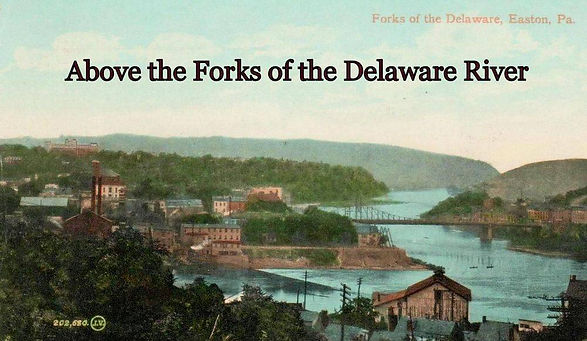
ABOVE THE FORKS OF THE DELAWARE RIVER
It has been researched in the past as to just where David Brainerd entered into the forks of the Delaware. Some have located his arrival as being on the west bank of the Delaware River, in the area across from Belvidere, N.J. Others have located him as entering at the town of Easton. Within Rev. Brainerd's diary, he states that upon his arrival (in Pennsylvania) on May 9, 1744, he met with the Indians in the Minisink Hills. Monroe County records show that in 1741, Azariah Horton, a friend of David Brainerd and both being Presbyterian Missionaries, arrived in the Minisinks, using the Old Mine Road (now River Road). Published 18th-century maps show the Old Mine Road crossing the Delaware River from New Jersey about 3 miles above Depew Island where the Walpack Ferry existed at that time. The maps show the road then follows the river southwest through the Minisink Hills and into the Delaware Water Gap area. From there, and after crossing several creeks, the road (now Cherry Valley Road) then continues southwest along the base of the north side of the Blue Mountain (also known as the Kittatinny Mountain Ridge), ending at the Wyoming Trail at the mouth of a gap in the mountain ridge called the Wind Gap. Following the Rev. Brainerd’s departure from the Minisinks on May 13th, he then writes that “I arrived at a place, called by the Indians Sakhauwotung, within the Forks of the Delaware.” Sakhauwotung in the Indian language means the mouth of a creek where someone resides. Rev. Brainerd writes that upon his arrival at Sakhauwotung, he is “12 miles above Easton.” Being 12 miles above the town of Easton, at the mouth of a creek, would locate him at the Wind Gap, which is where the Old Mine Road intersects with the Wyoming Trail and where Bushkill Creek runs on the south side of the gap and Smithfield Creek streams along the north side. Within geological reports, it is written that the Delaware River once flowed through the Wind Gap, before the great ice sheets from the north receded and the river once again flowed at its current location through the Delaware Water Gap.
Rev. Brainerd writes that at Sakhauwotung, he is “within the Forks of the Delaware,” meaning he has passed through the Gap in the mountain and is now on its south side where he was ordered to report, and where the town of Wind Gap is located at today. He also states upon his arrival at Sakhauwotung, that there is “a settlement of Irish and Dutch people.” Mount Bethel/Bucks County records show that in 1746, Robert Lyle, Esq., first laid out Mount Bethel’s original boundary lines. The records state that the boundary line is to follow the north branch of the Bushkill Creek and along the west side of the property of Jeremiah Best and to the Blue Mountain. A 1736 land survey shows that Best owned land that was about a mile southeast of the Wind Gap and was located between the east and west branches of Bushkill Creek. Other names shown on land surveys and located within the Wind Gap area at that time were: Best, Dietz, Mumbauer, Doll, Decker, and Keller. Many of those names are both Irish and Dutch German as the reverend had described them to be. Upon his arrival at Sakhauwotung, Reverend Brainerd states in his journal that he preached there to about 20-25 Indians and that an Indian king allowed him to use his house at will for that purpose. The main road through the Wind Gap at that time was known as the Wyoming Path. Upon the Indian migration from that area into the Wyoming Valley, following the Walking Purchase of 1737, some Indians had temporally settled there or had not yet left the area; the Indians being Chief Teedysung of the Delaware Tribe. Reverend Brainerd writes that from the king’s house he discoursed to the Indians and the settlers at the Wind Gap through the summer of 1744.
David Brainerd’s diary, states that by December of 1744, the Reverend had built himself a cabin. Mt. Bethel records from 1787, locate his cabin, about a mile, north by east from the mouth of Martin's Creek (about 10 miles southeast of the Wind Gap), that from his house, he travels 3 miles to preach to the Irish, Dutch, and the Indians. In July of 1745, he then records that when leaving his house he’s “upon the road”and then writes that he “preached to the white people”and “to the Indians 3 miles away.” From the reverend's house, in the area where a state marker platts it to have been located in 1787, and the reverend being upon a road and three miles away would locate him near the intersection of Kesslersville, Youngs Hill, and Lefevre Roads. There were many Indian paths that crisscrossed the area at that time, and upon 18th-century maps of the Plainfield and Mt. Bethel areas, only 2 are shown as being roads for horse and wagon travel. A 1749 map of Northampton County, shows the main road (Wyoming Path) leading north from the town of Bethlehem, to the town of Nazareth, and through the Wind Gap. The other road shows as being a local road that leads from the town of Easton, then north upon what is today Kesslersville Road, until intersecting with the Wyoming Path at the base of the Wind Gap via the current Alpha Road.

As a missionary minister, David Brainerd preached from the open air of the wilderness during his stay above the forks. But in October of 1745, he reports that he “went to the place of public worship.” In September of 1746, upon his return home at the Forks of the Delaware he records that he “arrived among my own people (the Scotch-Irish Presbyterians known as the Hunters Settlement), just at night found them praying together: went in.” In September 1738, The Forks of the Delaware asked New Jersey Presbytery to supply Pastors. The Reverend Gilbert Tennent was directed to go there and preach at the Hunters Settlement. The Scotch-Irish settlement arrived in the Mount Bethel area in 1730. On the mid-18th century land surveys, they show the settlement living mostly in the area along Kesslersville Road and east towards the Delaware River to the town of Martin's Creek. Also living within that area were the Dutch German settlers. They began migrating into the Mount Bethel area in 1737 and are shown on land surveys as also living along the Kesslersville Road, then mostly north to the Wind Gap. The reverend records in his journal that during his trips to Susquehanna, he was accompanied by Reverend Beatty. The reverend was pastor to Hunter’s Settlement before and during the Rev. Brainerd’s time there. The New Jersey Presbytery began sending pastors into the Forks of the Delaware in September of 1737 and is also when a log meeting house was constructed, a commercial building to hold church services in was then available (see below log meeting house built first in 1737 by Hunter's Settlement. It was built upon land acquired from Penna. Chief Justice William Allen).

The building that the Reverend Brainerd records that he went into, in September 1746, is the same building he preached outside of to the Indians and the local settlers 3 miles distant from his cabin, it was the log meeting house built in 1737 by the Scotch-Irish of the Hunters Settlement thence the Presbytery sent pastors into the area. Reverend Brainerd was not allowed to preach from within the church building as he was a missionary pastor. It is also where the Reverend Beatty sent by the NJ Presbytery preached before and during Rev. Brainerd’s time there and where the Reverend Tennent preached beginning in 1738. Some of the names located upon land surveys over the Kesslersville Road area during that time were: Chief Justice William Allen, David Allen, Chief Moses Tatamy, Robert Mathewson, Robert Campbell, Joseph Martin, and Robert Lyle. Those names are all shown as subscribers to Jonathan Edward’s 1749 publishing of David Brainerd’s diary and journal.
According to Mt. Bethel's records, by 1747, a new church building was built for the Presbyterians. The church was located near the spot where Rev. Brainerd records within his diary on the Lord's Day, Feb. 17, 1745 that he “preached in the wilderness on the sunny side of a hill, to a considerable number of white people, many of whom came near twenty miles, from Kreidersville to Martin's Creek. Discoarsed to them all day from John vii : 37. There were many tears in the assembly, and I doubt not but that the Spirit of God was there convincing poor sinners of their need of Christ.” According to reports from Martin's Creek and other nearby settlements, they later reported that "It was a source of much pleasure, to some of the older settlers, to say that they had heard David Brainerd preach".

Reverend Brainerd's Tomb, Northampton, Massachusetts
PLAINFIELD CHURCH
As the Presbyterians moved from the meeting house located on Kesslerville Road above the town of Easton, appeared also in 1747, the first records for Plainfield Lutheran and German Reformed

From the diary and journal of the sainted missionary Reverand David Brainerd from his time Above the Forks of the Delaware River. 1744 - 1745
Congregations. Traditionally the Lutheran and the Reformed worshipped within the same church building and with a new place of worship for the Presbyterians at Martins Creek, the Lutheran, and German Reformed Congregations acquired, or continued worshipping within what became the first Plainfield Church building; located on Kesslersville Road and where David Brainerd preached outside of and prayed inside.
Adam Dietz, an early founder of the Plainfield Church, is found on land surveys, as migrating north from the Lower Saucon and towards the Wind Gap in Plainfield Township, beginning in 1739. By 1747, the first record for the Plainfield Church appeared (the year Rev. Brainerd died). The record states that Adam Dietz is to secure a tract of land for both the Lutheran and German Reformed congregations. In 1750, a land warrant was claimed by Adam for 26 acres and was put “in Trust for the Calvinist Congregation,” (Calvinist, also called the Reformed Christianity). The warrant states that the 26 acres were located near the land of George Berringer. A 1745 land warrant and survey show that Berringer’s land was situated about a one-half mile southwest of where the Plainfield Church Cemetery is located today at Delabole and Church Roads. The 26 acres were then used by the Lutheran and Reformed Congregations for cemetery purposes as was the custom to first secure a burial ground before anything else. By 1750, the Plainfield Church congregations had secured 26 acres of cemetery grounds. The congregations also had secured a church to worship in that was located on Kesslersville Road and located about 3 miles south-east of the cemetery.
As the church congregations and the area grew, taverns and inns were a sure source of income. Adam Dietz was granted a license to run a tavern in 1752, and upon his December 1756 tavern license renewal it states that the tavern is located “upon the local road leading from Easton to the Minnisinks near a place called the Wind Gap where formally Petitoner and Jno (John) his Son have kept a Public House.” The meeting house evidently was still being used as a tavern following the Hunters Settlement/Presbyterian's time there. Prior to the tavern license in 1752, records reveal that on August 3, 1750, Conrad Weiser and his son-in-law, the Reverend Henry Mullenberg, upon their travels to the Minisinks, reported within their journal that they were 5 miles above the town of Nazareth where they stayed the night at a tavern. Five miles above Nazareth (via an 18th-century bridal path known today as Lefevre Rd.), is where Lefevre, Kesslersville, and Youngs Hill Roads all intersect with each other. From this record, it is evident that a meeting house existed there. The meeting house, also being used as a tavern and Inn during David Brainerd’s time in the area would explain the reverend's journal entries that when discoursing to the settlers and the Indians, 3 miles from his house, some were belligerent towards him and he would preach to those that “seemed to be sober.” During the 18th century, meeting houses were the downtown of a settlement. The buildings usually stood one and one-half stories tall and about 25-foot square and were built of stones or logs. A meeting house accommodated a settlement for multiple purposes such as a place for worship, a school, a hotel, a tavern, etc.


The first Plainfield Church was built upon land aquired by the Scotch-Irish from Chief Justice William Allen. Justice Allen owned 12,000 acres of land in the areas from the Wind Gap, in Plainfield, to Martin's Creek in Mount Bethel. Mount Bethel records show that the land for the Scotch-Irish (Hunters Settlement) for their new church built in 1747 was also acquired from justice Allen. The Scotch-Irish also built the log church (above) by September 1737, for in that year is when the New Jersey Presbytery sent regular pastors into the area above the forks of the Delaware.

The Scotch-Irish had their own unique designs in their building methods. They would center a door between two windows. In the photo at left, is a stone church building the Scotch-Irish built in 1753 in the Minisink Hills located north of where the log meeting house was located. Notice in the photos (above), just left of the top of the doorway, the cut pieces of log timber. It may be it was during a renovation of the meeting house between 1800 and 1805 that the Dutch-German builders redesigned that doorway and moved it to the right side of the building. (above photos)
Rediscover the log church that the Reverend David Brainerd preached and prayed at during the Great Awakening. From a recently discovered Deed with this log meeting house, it tells a story of when it was used by Benjamin Franklin as a blockhouse during the French and Indian war (1754-1764). This storied discovery begins with the onset of the French and Indian war in Northeastern Pennsylvania. Located above the forks of the Delaware River, on the local road leading from Easton to the Minisinks, near a place called the Wind Gap in the Blue Mountain.


THE SAINTED MISSIONARY REVEREND DAVID BRAINERD AND THE GREAT AWAKENING
Thank you, for your donation. - Jon Sinatra
