

THE TIME IS COMING WHEN EVERYTHING THAT IS COVERED UP WILL BE REVEALED, AND ALL THAT IS SECRET WILL BE MADE KNOWN TO ALL.
LUKE 12:2
BreakOnThru.org
DISCOVERING THE FUTURE BY REVEALING THE PAST
ZUNIGA MAP, ELANNOR DARE
and the
LOST COLONY of ROANOKE
INTRODUCTION
*****
It is known as the Zuniga map. The map could not have been solved without a creative eye and technology such as Google Earth. In sharp focus, one must be able to zoom in on certain targets within a few hundred feet from a birds-eye-view. Some targets also must be viewed in the different seasons of Winter, and Summer. A way to measure distances is also needed and Google Earth provides this. In laying the map out horizontally with the rivers running east and west over the south-east Virginia region from the Chesapeake Bay, then west and north past Jamestown shows to be somewhat in line with many of those areas although historians and scholars have not agreed on the interpretation of its geography. There are many Indian camps throughout the map that show no sign of occupation in their excavations. The Indian camp names are written sideways. A paragraph in the upper right corner of the map is also written sideways which makes no sense at all as there is room to accommodate all of the copy to read from left to right and top to bottom. Jamestown's Capt. John Smith when referring to the Zuniga Map said that it was a map of Virginia. But at that time North Carolina was also a part of Virginia.
Turning the map vertically, the copy then reads correctly from top to bottom. The rivers run north-south and the Zuniga Map then lays over north-east North Carolina. The map is of the north side of the Albemarle Sound, from the Currituck Inlet, west to the town of Edenton, and south-west to the islands in the Roanoke River just off of the mouth of the Albemarle Sound. The map then proceeds north along the Chowan River to just past the Arrowhead and Chowan Beach areas on the east side of the river. Historian and author David Beers Quinn writes, "Clearly the Zuniga map is of the greatest importance in showing us what was known and surmised in 1608 as to the area south of the James (River)." Mr. Quinn is referring to the 1587 English colony, also known as the Lost Colony of Roanoke and their fate south of the James River.
The Zuniga Map has been solved! And it is not of the Chesapeake Bay region or the James River as has been previously suggested. Found written upon the map multiple times is a 1587 Lost Colony leader Elannor Dare's name. A copy drawn from the original map by the maker (below) is in black and white and any color upon the map was recently added for identification purposes.
CHAPTER I
*****
THE ZUNIGA MAP
The Zuniga map is not a map per se, it was not made for directional purposes. There is no scale to the map and there was no engraving of it ever made. A couple of traced copies from the original were made by the artist and the map (above) is one of those traced copies. Only a small section of the original has been released into the public domain and some pieces of that section are used here to show certain details in a sharper quality.
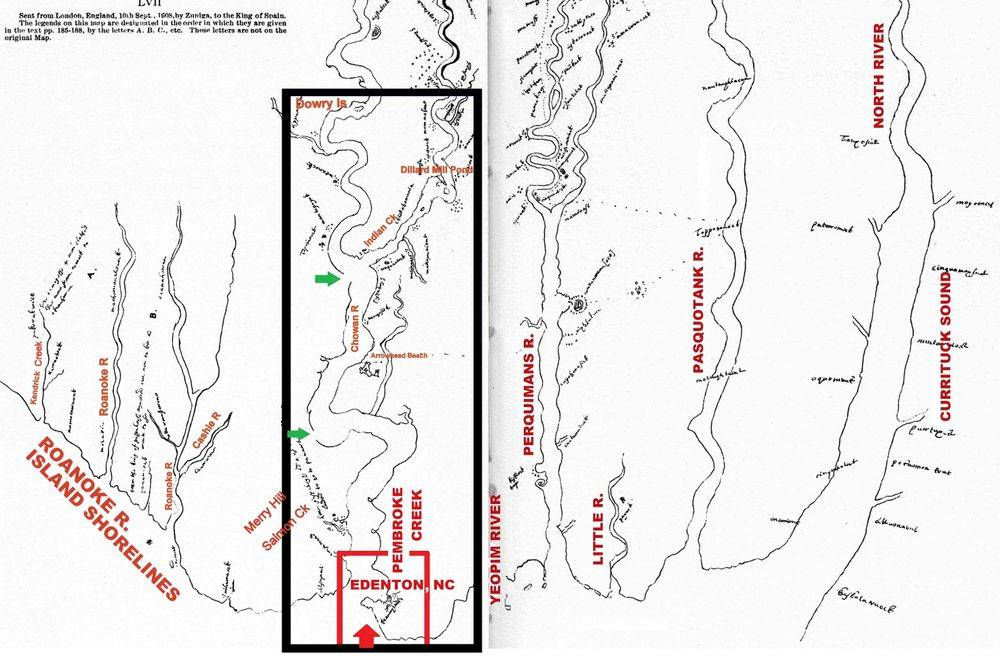
Pedro de Zuñiga (Zuniga map) was the Spanish ambassador stationed in London, he obtained a copy of the map for King Philip III of Spain. The map shows the areas where survivors from the 1587 colony had been and where they are currently located. Within the black border (above), those areas represent Edenton, NC, Pembroke Creek, the Rocky Hock Creek, the Chowan River, Indian Creek, to the Meherrin River. Note the entire landmass west of Pembroke Creek to the Chowan River and north to the Rocky Hock Creek inlet is missing. It shows the west bank of the Chowan River as being the west bank of Pembroke Creek. There are 2 "breaks" on the map (above, at green arrows) that leave those areas open for interpretation of distance. Most of the lines on the map are very exact in that the smallest drawn detail that appears to be a careless mistake actually represents a landmark that still appears there today. Although many of the map's dips, curves and straight lines are not to scale, they do mimic the dips, curves, and straight lines of certain areas. The far left of the map shows the Roanoke River. The beginning of that area matches up exactly with the shores of the islands where the river begins at the mouth of the west end of the Albemarle Sound.
On the map (below, left, at blue arrow) there appears in the Roanoke River a watercourse with a short, "squiggly" tail. Most of that watercourse is made up of a "squiggly" tail (below right at blue arrow) and is an example of the map void of any scale but is similar in nature.


Identifying many of the locations on the map is in the fine detail. For example, in the image (below, left), the map shows a short run of the Cashie River, the artist refers to it as the Chowwan. There is a line that spans about 2/3 of the way across the river where the Roanoke and Cashie Rivers meet (blue circle). The Google Earth satellite photo (below, right, blue circle) shows what the artist was referring to with that line. The small "islands" shown in the river are not identified as the map was not made for purposes of identifying areas.


The image in the black, rectangle border (above map), is used on this page with color-coded borders for easier identifying of the different areas, that image when used here runs east to west for easier viewing.
FROM ROANOKE ISLAND, TO EDENTON, NORTH CAROLINA (below)

Within the image (above) north is facing south. Within the image (below) north is facing west. In the red boxes (above, and below) is where today Edenton, North Carolina is located. Edenton is also where the Lost Colony landed at 50 miles into the main interior following their move from Roanoke Island. Elannor Dare's profile bust picture displays as a knob of land that jets out into Edenton Bay (above and below at red arrows). Her name was written by the artist beneath her image and is translated above the red line (above, right window).

FROM EDENTON, NORTH CAROLINA, TO THE CHOWAN RIVER / ROCKY HOCK CREEK INLET (below)

From the town of Edenton (above, red arrow), Pembroke Creek runs NW winding around knobs of land and islands. The path then turns west and extends to another island located in the Rocky Hock Creek inlet just off the Chowan River (above and below, at yellow arrows). The artist is not making a true map per se and therefore some of the details of the lay of the land are bypassed and are not included in the drawing. The lines drawn on the map linking together the islands, overlay the same straight and curved lines on the satellite map (above) as there is no scale to the map but their paths are similar in nature.

FROM THE ISLAND AT THE CHOWAN RIVER / ROCKY HOCK CREEK INLET, TO NORTH OF BENNETT MILL POND (below)

Within the water inlet that encircles the island at the Rocky Hock Creek, there shows a heavy, curved line drawn just off of the island (above, blue arrow at far-right). That curved mass appears as a treeline visible in the water next to the island (above, blue arrow, at left.) Heading north from there is Bennett Mill Pond, and Just north of the pond appears a water hole that is unique in its appearance (above, white circle, and below, black circle at white arrow). From that water hole, the map plots a course NW.

FROM NORTH OF BENNETT MILL POND TO THE EAST BANK OF THE CHOWAN RIVER NEAR CHOWAN BEACH and ARROWHEAD BEACH (below)

From the unique shaped water hole (above, white circle), the creek runs NW and branches off in multiple directions (at blue circles). The chart shows one of those branches extending north towards Indian Creek near Arrowhead Beach. At the point where the course branches from the creek (blue circle) appears a "slot" shape in the treeline (above, blue circles). The map also shows the "slot" shape in the treeline (below, blue circle at the blue arrow). That unique landmark is visible on Google Earth only in the Winter image of 1998.

FROM A BRANCH OF THE ROCKY HOCK CREEK TO THE DILLARD MILLPOND (below)

Extending from the "slot" (blue circle at blue arrow), a branch of the Rocky Hock Creek flows north (above, outlined in red) past Chowan Beach and Arrowhead Beach, the creek then ties into Indian Creek. Heading northeast along the Indian Creek is Dillard Millpond (above and below, top at right, red and yellow arrows). The chart shows 2 unique shapes in the pond area (above, right, red and yellow circles). In both red circles, they show a circular cutout around the shore of the pond, note there is a flat side to the pond (above, far-right image). The other is a bush (above, yellow circles). The bush appears basically in the same shape as it appeared over 400 years ago when the map was made. What also appears to be an island in the creek (top, blue circle), is a circular clearing in the brush and trees. There are a few of those "circular" clearings along the creek in that area but only one is most closely shaped like the one that appears on the map. The short lines on the creek's banks above the clearing are small streams that runneth over from the creek.

ARROWHEAD BEACH, CHOWAN COUNTY, NORTH CAROLINA (below)

Along the Arrowhead Beach shoreline appears a white sandbar, darker sand appears mixed in on the left side of the sandbar (above, red circles). The artist then simply squared off a watercourse (blue circles) that cuts into the bank. He then continued along the shoreline to a notch that is naturally also cut into the shore (left and right, green arrows). The area within the gold circles (above) shows a darkened mass. In that area, the trees are of a different shade of color than the darker green trees and make for an identifiable landmark that clearly stands out when viewing from a birds-eye-view. To the right of the gold circles, appears a path through a clearing that crosses over the creek. A roadway now runs over that path (above, b/w dotted lines at left and right, and below in the dark blue box). The A-shaped icon with a Cross (above) that appears to be a fort is a church built by the Lost Colony. More information about that church can be found further down on this page.

FROM ARROWHEAD BEACH TO THE ROANOKE RIVER

Navigating the Zuniga map from east to west ends at the Roanoke River. What has been thought in the past to be the North Carolina coastline, are the shorelines of the islands at the mouth of the Roanoke River. Those shorelines match up exactly to the shorelines on the map. The map shows the Roanoke River (see "Roanoke R." above, inset window) as a straight, "squiggly" line. The map also names that "squiggly line "Morattic", the name the Indians used for the Roanoke River. The river winds around the islands in multiple branches until just west of the Cashie River where it forms as one and winds its way west. The map also shows one of those islands as Lanor Isle, or El - anor Isle, for Elannor Dare (above, blue circles). In the area of those islands, 7 survivors of the Lost Colony were taken there by the Tuscarora to the Hocomawanack Village and Oconohoen, also known as Ritanoe according to reports from Jamestowne and the Virginia Company of London. The map shows 2 Hocomawanack villages; 1 on an island in the Roanoke River, and 1 on the west side of Kendrick Creek on the Roanoke River's south bank (see above). Also on the map, there appears an island that is labeled "Roanoke" (above, green circle). The island is located at the entrance between the north bank of the river and the first island. Although there is no island located there, the artist is showing that the Lost Colony came from Roanoke Island where they first landed in August of 1587. The Albemarle Sound and Chowan River areas were also referred to as "Roanoke" according to reports from Jamestowne.

SOLVED: The Zuniga Map
Thank you, for your donation! Please see additional chapters below. - Jon Sinatra

